News
Into the Piloting Practice Waters

Craig Marin, Assistant Professor of Maritime Studies
Ship’s Log
Current Location
Anchored in Sakonnet River
Weather
Overcast with occasional rain, wind ENE Force 2
All blogs from C-294
On our fourth day in program we are taking advantage of our proximity to shore to work our way up into a protected anchorage that should look very familiar to students (at least as they gaze at the chart in the pilot house). This river and its entrance were key elements in one of their piloting exercises on shore. Now they can see how the channel, the landmarks, and the navigational aids look in person.
 Afternoon snack and Katey’s galley art!
With that wet and windy forecast noted in the previous blog in the forecast for Rhode Island Sound, Buzzards Bay, and the waters further offshore, we have remained at anchor to give students a more stable platform as they continue to find their way around the ship and adjust to their moving home.
This also gives everyone the opportunity to work through the tasks of the watch system in groups and help each other through the routine of life at sea from boat checks (making sure all parts of the ship look, sound, smell, and feel normal) to using navigational tools to verify the ship’s position and monitor any other vessels moving around in the river.
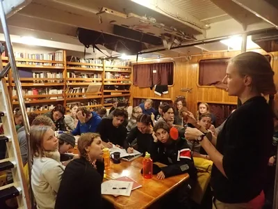
Speaking of navigational tools, our main event in class today was a lesson in vessel lights from their names and locations on the ship to their interpretation and use at sea. Creatively refashioning some footwear (with pencil spars and construction paper “lights”) into a sailing school vessel, our second mate, Carolyn, demonstrated all of the different combinations of navigational lights we use and described how other vessels near us could interpret them at night. With a little added demonstration of some different vessels and their lights, students are now primed to work with their mates at night to pick out a distant vessel and make sense of its size, purpose, and direction (before looking at one of our instruments, the AIS, to verify what they see).
Of course, every day is a good day for science, and the lab has been busy over the last two days collecting and processing sediment, assessing water chemistry, and gauging the depth of light penetration beneath the surface.
Student projects are already underway in terms of data collection, and when we head out later this afternoon, deployments will continue as students become more familiar with the workings of the ship’s lab and science gear and we collect even more data for student projects as they begin to test their hypotheses crafted ashore.
As I type (at 1700 ship’s time), we are preparing to get underway again. Stay tuned for more details on the experiences of the crew of the Corwith Cramer over the rest of this six-week passage!
– Craig Marin, Maritime Studies
Editor’s Note: In response to the coronavirus pandemic, all SEA Semester students, faculty, and crew aboard the SSV Corwith Cramer boarded the ship after strictly isolating on our Woods Hole campus for a minimum of two weeks, and after repeated negative tests for COVID-19. To ensure the health and safety of those onboard, the ship will not conduct any port stops and will remain in coastal waters so that any unlikely medical situations may be resolved quickly.